The Geography
of Menmuir
Of all the areas within the Angus
Glens, the parish of Menmuir best epitomises the dual character of the
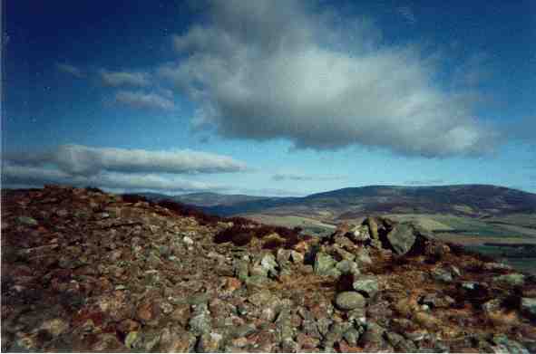
landscape of north-eastern Scotland. If one climbs to the top of one of
its ancient hill forts, the Caterthuns (Link to Caterthuns on History page),
and faces south-east, the view stretches over typical Scottish Lowlands
down to the North Sea at Montrose: rich farming country, substantial farm
houses and the woodlands of great landed estates, crossed by the lower
reaches of two of the country's great salmon rivers; a land of agricultural
wealth and ancient market towns such as Brechin and Forfar, but linked
to north and south by excellent communications including the A90 trunk
road.
Menmuir straddles the line
of the Great Highland Fault which separates highland from lowland, and
the view to the north and west is of the heather covered hills surrounding
Glen Lethnot and Glenesk, the vanguard of a hundred miles of virtually
unbroken mountain scenery, rising and stretching to the Atlantic coast,
with an economy founded on grouse, deer, and tourism.
Menmuir is partly bounded on
the north by the West Water, the main tributary of the North Esk, and the
Cruick Water flows through the southern areas of the parish.
View from
the White Caterthun
Back to Menmuir